It was early in the morning, but the summer sun was already high above the horizon. I squinted, fumbling to find my sunglasses, as I drove racing against the clock to get to the project site before our partners and volunteers arrived. I slowed among a line of traffic. Traffic?! This was shocking considering I was on a two-lane country road between rural towns in Western Colorado, neither of which even boasted a stoplight. I nudged out from behind the line of cars to glimpse at what was causing the delay. A few hundred yards ahead were cattlemen on horses and ATVs flanking a large (and slow) herd of cattle. I tapped my steering wheel with my thumb and followed suit as cars meandered through the herd to the other side.
When I got to the project site, I was greeted by my co-worker and the property care-taker, Terry. Terry was an older man, his skin carried the sun in deep wrinkles and dark spots, his hair was bleached white. He had lived in a small house on the property for a long time and was tasked with managing surrounding irrigation canals. He walked us out to the project site, cigarette in hand.
The project area was located in a meadow that was marked with the distinct cut of a streambed. Except, there was no water running through its channel. Looking at the dry soil in its base, it was hard to imagine when there was ever enough water running through this meadow to create an incision this size. However, this is common in meadows where there are gradient changes. As the gradient becomes steeper, the rate water flows increases and can cause erosion. Once erosion begins, the incisions tend to grow larger and deeper with runoff and rainfall events, allowing water to move faster and erode the soil more.
streamdynamics.us/sites/default/files/resource-docs/nrcs
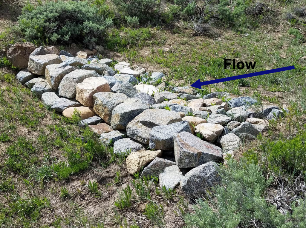
Our project was to address this feedback system by constructing rock structures that “slow the flow”. Called a variety of names and varying slightly in style, practitioners may refer to these structures as zeedyks, zuni bowls, one rock dams, and media luna (Natural Resources Conservation Service). The critical element of the structure, featured in the picture here, is the dam-like wall that is built by filling the incision with rocks, allowing water to flow over a shelf onto a lower level of rocks. The top part, where the “flow arrow: is located, slows the water to increase infiltration. If all of the water does not infiltrate and it continues flowing, then the lower rock level protects the soil and limits undercutting as the water drops in gradient. The long term aim of these structures is to support revegetation and stabilize the soil.
While this project is located in the North Fork Valley of Colorado, most research around these structures is coming out of Colorado’s Gunnison Valley. With demonstrated success, these projects are becoming increasingly more popular throughout the state. For landowners looking to implement these projects, there are limited equipment costs, raw materials are inexpensive and/or can be found locally, and can facilitate collaboration during project implementation. In addition to the benefits such as reduced erosion, improved water quality, and increased biodiversity, wet meadow restoration projects also benefit agricultural producers by improving forage and grazing lands. Our collaboration research project with Colorado Cattlemen’s Agricultural Land Trust focuses on these structures as opportunities to improve habitat, engage landowners, and connect community members within the Yampa River Valley.