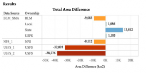
This is an inter-agency project led by the U.S. Fish and Wildlife Service and the U.S. Geological Survey. Federal and State agencies frequently respond to requests for analyses of land status within the sagebrush biome, such as acres of land ownership or management designation. However, across agencies the results are inconsistent. The goal for this project is to provide reconciliation of differences where possible, written documentation of why differences exist, and identification of a consistent dataset to be used by USFWS and multitude of other state, federal and NGO partners. Our research assistant is assisting the project by reconciling overlapping layers and inconsistent data forms, calculating the amount of land owned and managed by various parties (i.e., state, federal, private, tribal) contained within jurisdictional boundaries and areas of interest. Outcomes will provide a standard process and products that save time and reduce confusion, as well as describe where and why we might expect to have differences in land ownership calculations.
Collaborator
U.S. Fish and Wildlife | Website
Project Deliverable
Student Researchers
Ben Williamson, Research Assistant | Ben is a Masters of Environmental Management (MEM) candidate at the Yale School of Forestry and Environmental Studies. Originally from Colorado, Ben has a BS in Ecology and Organismal Biology from the University of Montana. His early interest in wildlife biology led him to positions with the National Park Service, the Glacier Institute, and Natural Resources Defense Council. At Yale, he is building on his science and education background, to craft a career path in land use policy and governance. See what Ben has been up to. | Blog

