– Project Partners: Ucross High Plains Stewardship Initiative and The Nature Conservancy (Wyoming)
– For more information, please contact Sabrina Szeto (sabrina[dot]szeto[at]yale.edu)
Sagebrush (Artemisia spp.) landscapes across North America are an important habitat for more than 350 species, including 207 species of conservation concern in the Great Basin ecoregion alone [1]. Sagebrush once covered around 630,000 square kilometers of the Intermountain Region and the Northern Great Plains [2], but this area has since shrunk to around 430,000 square kilometers. Land use change arising from agricultural, urban and energy development, as well as increasing fire frequency and human population density, have all contributed to the loss, degradation and fragmentation of sagebrush [3]. The loss of sagebrush habitat threaten the continued survival of many sagebrush obligate species, including the greater sage-grouse (Centrocercus urophasianus).
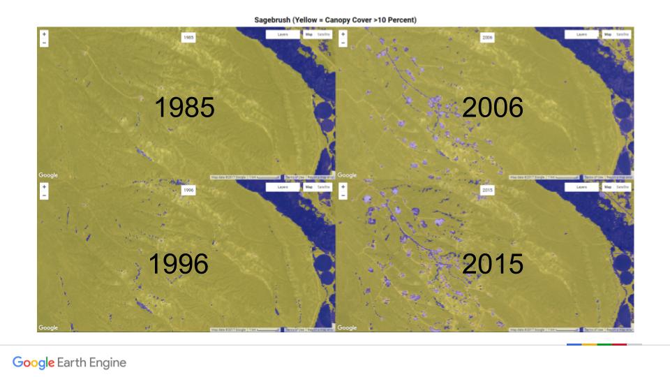
Continuing efforts to protect vital sagebrush habitat for species like the sage-grouse will require long-term monitoring of the abundance and distribution of sagebrush to track progress and prioritize areas to maximize the use of resources. While there has been important progress in using remote sensing to map sagebrush abundance and distribution, no large-scale monitoring platform exists at the moment. There is also a trade-off between spatial and temporal resolution – either large areas over a short time period, or small areas over a longer time period have been studied. In addition, these sagebrush mapping studies are not easily accessible by land managers. We thus propose to create a real-time monitoring platform for sagebrush designed for use by land managers, using machine learning algorithms to classify Landsat imagery on Google Earth Engine. A few maps from SageTrends are shown in Figure 1 below.
Figure 1. Four classified sagebrush cover maps from 1985, 1996, 2006 and 2015 over the Pinedale Anticline area in Wyoming where energy development has led to a loss of sagebrush cover. Yellow areas show sagebrush cover over ten percent and blue areas represent all other land covers.
The SageTrends platform will be easily updatable and accessible by land managers like ranchers, community groups and government agencies. By writing a script which can take new satellite imagery as inputs every year, we will be able to create an easily updatable dataset which will be publicly available – just as Global Forest Watch has made global forest cover data accessible to users around the world. It could also be possible for land managers to upload a shapefile or draw a polygon around their property boundary to obtain location specific information, as is possible on the Fence Collision layer on the Sage Grouse Initiative map.
As stated in the Integrated Rangeland Fire Management Strategy Actionable Science Plan (October 2016), developing “next-generation mapping techniques to provide regular interval updates” every two to five years is a pressing science gap. We believe that SageTrends is poised to fill this need and welcome collaboration from partners to further develop this platform.
Literature cited:
[1] Suring LH, Rowland MM, Wisdom MJ. 2005a. Identifying species of concern. In: Wisdom MJ, Rowland MM, Suring LH, editors. Habitat Threats in the Sagebrush Ecosystem: Methods of Regional Assessment and Applications in the Great Basin. Alliance Communications Group. p. 150–162.
[2] West NE, editor. 1983. Western intermountain sagebrush steppe. In: Temperate deserts and semi-deserts. Vol. 5. Amsterdam, The Netherlands: Elsevier Scientific Pub. Co. p. 351–374.
[3] Miller RF, Knick ST, Pyke DA, Meinke CW, Hanser SE, Wisdom MJ, Hild AL. 2011. Characteristics of Sagebrush Habitats and Limitations to Long-term Conservation. In: Knick ST, Connelly JW, editors. Greater Sage-Grouse: Ecology and Conservation of a Landscape Species and Its Habitats. Vol. 38. Berkeley, California, USA: University of California Press. (Studies in Avian Biology). p. 145–184. [accessed 2016 Nov 8]. http://muse.jhu.edu/book/26026