Before taking measurements during bustling recreation events—assessing plant height, counting species diversity, recording sound levels, reading water qualities, and comparing soil compaction images—it is crucial to read ecosystem distress calls through careful observation. I call this ‘read’ a qualitative query, which involves discernment and meaningful observation of natural surroundings. Ecosystem or ‘ecological distress signals’ occur when species, habitats, and ecosystems deliver various warning signs. Scanning for warning signs can inform site selection, enrich methodologies, and promote more robust research aims, ultimately assisting researchers when deploying ecosystem-based studies.
These warning signals often herald changing resource conditions via ongoing disturbances, and although challenging to tell the severity (i.e., how far long and the impact’s extent) without understanding the landscape’s full story, it is crucial to carefully listen. Tuning into the natural complexity and multiplicity of human-nature happenings allows us to capture paramount ecological puzzle pieces. These puzzle pieces greatly assist researchers and others who are interested in conserving ecosystems used for recreation by multiple user groups as well as non-humans, such as wildlife.
When centering attention on mountain watershed ecosystems, including streams, wetlands, riparian zones, wildflower-dense spaces, and adjacent forests, ecosystem distress calls often reveal signs. These distress calls are often manifestations indicating site overuse. There are several universal signs, commonly viewed across all ecosystems, which include bare shorelines, compacted surface soils, poor water clarity, homogenous plant and animal encounters, noisier and less complex soundscapes, rubbish-covered sites, and growing infrastructure (i.e., nearer roadways, parking lots, restroom facilities, trail design materials). The figure below displays a field site with easy roadway access near the headwaters of Big Cottonwood Creek. This site receives many ‘pullover’ visitors, or those desiring a small break before entering one of the National Forests’ multiple-season mountain resorts, solitude, or continuing over the mountain toward southwestern Wyoming.
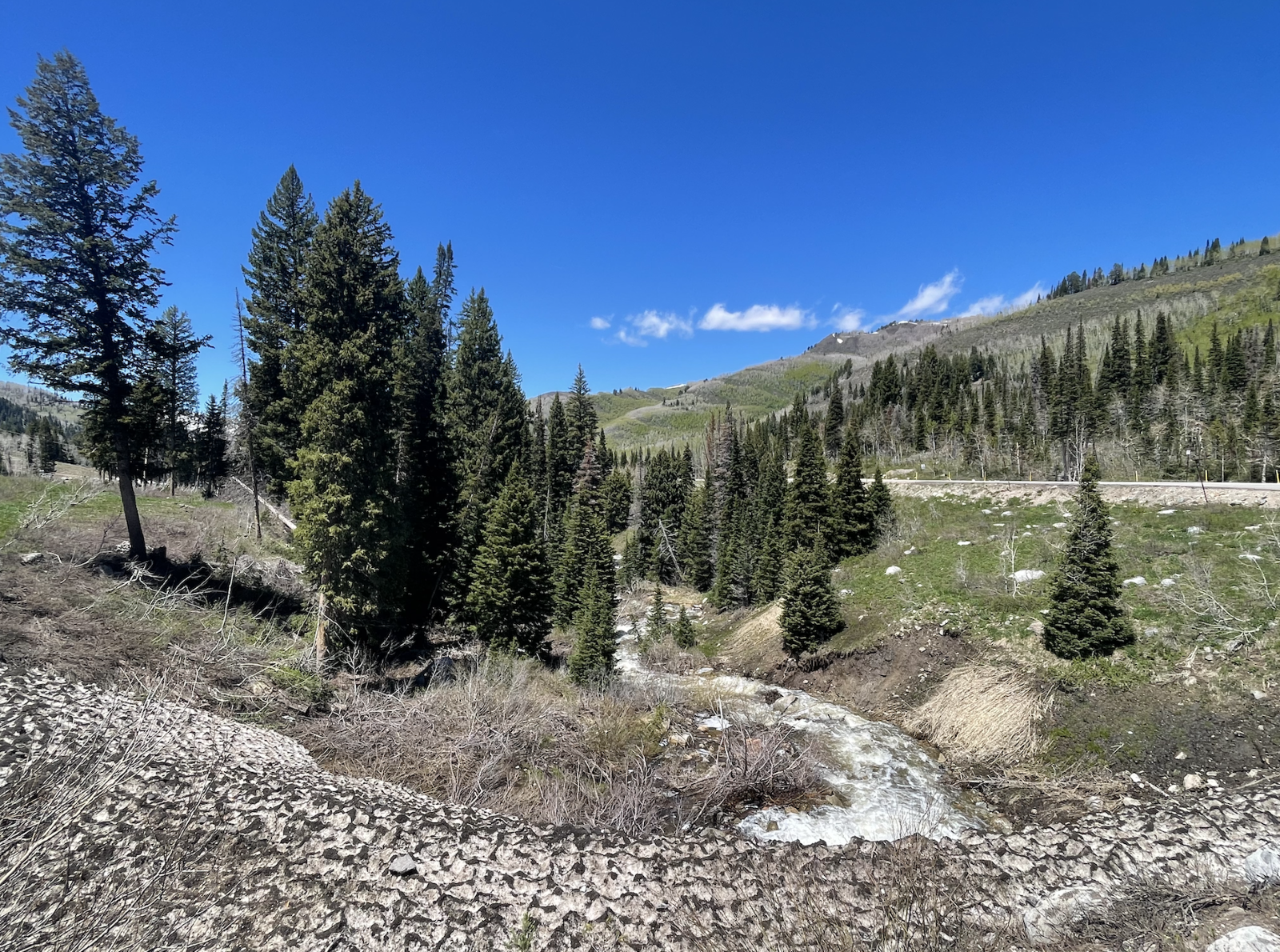
Roadway pullover showing gradually melting ice and the stream, situated near the middle of Big Cottonwood Canyon, Uinta-Wasatch-Cache National Forest (Joshua Kesling, 2024)
I fully recognize the value of these infrastructure elements to maintain visitor satisfaction, minimize hazardous conditions, and above all, reduce equity barriers so that all people can access their public resources. While I acknowledge the contribution of these outdoor recreation components to visitors, these artificial ‘additions’ indicate changing conditions, many with the potential to inhibit ecosystem integrity in recreation areas.
Aside from infrastructure, I commonly viewed bare and depauperate (i.e., systems with declining biological diversity) shorelines. Without healthy and structurally intact shorelines, both humans and (non)humans struggle to derive much benefit. Activities involving fly-fishing, shoreline walking, picnicking, camping, and wildlife viewing often depend on healthy shorelines, and although overuse does not occur overnight, it can quickly permeate the system. The figure below depicts a popular ‘sitting and hammocking area’ within a larger picnic site.
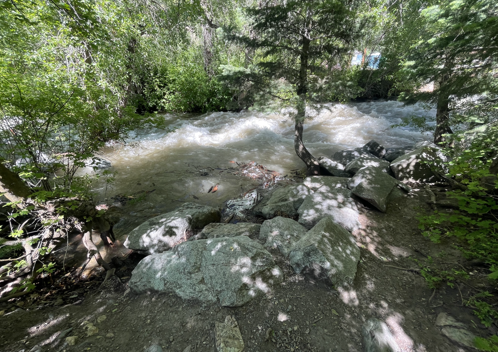
Ledgemere Picnic Area, situated near the bottom of Big Cottonwood Canyon, Uinta-Wasatch-Cache National Forest (Joshua Kesling, 2024)
The mountain picnic area receives close to 200 unique visitors each day, and these numbers often exceed 250 during popular Friday and Saturday evenings, given the ideal conditions. Two hundred and fifty individuals do not sound alarming or ecologically overwhelming, but for a riparian site, the ‘breaking’ point wavers. Note how the medium-sized boulders and soil have not developed moss or fungi. Lithophytes (i.e., species that grow on geologic surfaces) should cover the riverbanks because of frequent river-water sprays, which occur when windy conditions interact with flowing water.
Moreover, grass and wildflowers should diffuse across this site too, but only resilient woody shrub species reside. The soil is also highly compacted, which raises questions about the density of visitation and overall space treatment. Ledgemere displays distress signals in the form of barren rocky elements and powdery soil, and now, the National Forest must contemplate whether to further examine this issue or pursue another popular riparian site.
Next time, I will discuss some of my latest wildlife encounters, and specifically address why sightings within popular recreation ecosystems are concerning. The fate of large mammal conservation and critical animal-river dynamics hang in the balance, given changing resource conditions. I will also describe how to classify recreation-based disturbances based on activity types and frequencies.