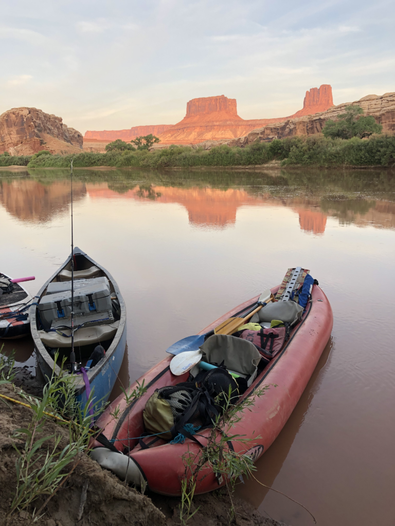
Over the course of 14 days this August, I traveled down the calm waters of Labyrinth and Stillwater Canyons of the Green River and the raucous and roiling waters of Cataract Canyon on the Colorado River. I went on this journey after a summer of conducting interviews and thinking critically about the role of the outdoor recreation economy in rural communities in the American West. Spending 14 days on the river felt like the ideal bookend to the summer—a way to consider what I’d learned, away from other distractions, as well as be reflexive as I contemplated the ways in which my own experiences of outdoor recreation validated or differed from the narratives I identified from my research. Here are a few thoughts from that journey.
The Green River is not, in fact, a green river. The Green River’s water is red and hot and heavy. Like blood. Like blood, the Green River is a lifeline—one of the arteries of life in the red rock desert of southeastern Utah. The Green River, though the water is red, does allow for many shades of green vegetation to grow on the banks. The dusty blue green of sharp smelling juniper. The brighter green of willows hanging low on the water. The sickly green of invasive tamarisk, clinging to the banks, planted by early colonizers to control the river. The hubris of some humans, to think that they can control a river.
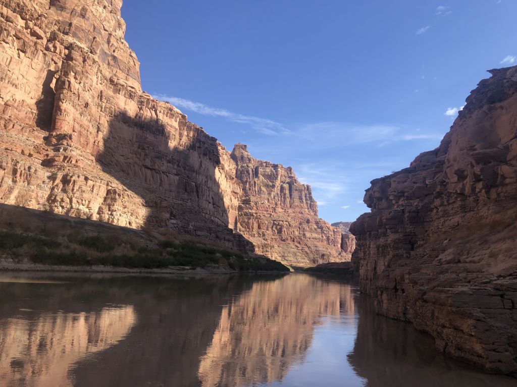
On the banks of the Green River, I sat in a puddle of shade, provided—for a moment—by the red rock cliffs that rose above. The cliffs were Wingate sandstone—a formation from the early Jurassic or late Triassic ages, some 200 million years ago. In the present echoing the past, like a shout bouncing between canyon walls, 200 million years ago, the place I sat was also a desert—windswept, dry, and arid. Miles and miles of sand dunes 100 feet tall. After millions of years, the Wingate had transformed from soft sand dunes to sharp cliffs, vertical cracks splitting the faces of rocks. From a distance, these cracks appear like clean cuts, razor sharp edges. Is it the blood of the cliffs that make the river red? I thought idly, craning my head to the rim of the canyon until I felt dizzy. Licking my dry, cracked lips, I took a sip of warm, heavy water. Though we had settled the Green’s silty water to something pure enough to drink, the water was still mineral and thick. The blood of my cracked lips mixed with the blood of the water and no matter how deeply I drank, I still felt vaguely thirsty.
The shade provided relief from the hot, demanding sun and 100-degree temperatures. I sat in the shade, a book on my lap, re-reading Terry Tempest Williams’ Red: Passion and Patience in the Desert. Williams writes an elegant equation in the introduction to the book: “Place + people = politics.” This equation is simple, yet profound–true of any place. However, on the banks of the Green River, the truth of the concept felt especially insightful.
Sitting on the banks of the Green River, I felt the intersections of place, people, and politics in a visceral manner. The land I sat on was Bureau of Land Management (BLM) land, public lands violently stolen from the Ute people by Anglo and Spanish colonizers, who stole the land and committed genocide for increased territory and mineral wealth, denizens of manifest destiny.
Signs of this violent colonization were abundant—inscriptions on rock walls and rusting refuse from uranium mining dotted the banks of the river. Pre-colonial times could also be seen on the landscape—carefully constructed stone granaries in rock alcoves, watch towers on buttes. Petroglyphs and pictographs, depicting families and creatures and spirits, hidden high on sandstone walls. Not all these places were written in the guidebook. Each exclusion felt like a gift, protecting the place from visitors such as myself who, no matter how good or thoughtful our intentions, disrupt the place and the people to whom to this was and is home.
The red rock desert in which I sat is also a place of current politics—of people fighting over and for place. South of where I sat is the Bears Ears National Monument, where in June 2022, after decades of hard work and negotiation, five tribes will now co-manage the land with federal agencies in a historic agreement. South is also White Mesa, Utah, where the Ute Mountain Ute contend with proposed uranium production and storage, a threat to human and environmental health. The trip I was on had staged in an Airbnb in Moab, UT, where a housing crisis makes affordable housing a profound challenge for those who call the region home. In Moab, we’d passed new development and freshly bulldozed desert—a testament to the latest boom economy of mountain bikers, National Park hikers, OHVers, dirtbikers, climbers. River runners. Us. Me.
The water of the Green is also garbled by politics—the doctrine of prior appropriation giving the West’s water to the first people to claim it (excluded, of course, from initial appropriations the Native people who had called the land and water home for time immemorial). Unfortunately, when water was allocated more than a century ago, it was predicated on faulty science and wishful thinking, over-allocating the watershed even before the West would swell with thirsty fields and cities. Sixty miles from where I sat—a place I’d paddle to over the course of the next few days—was the confluence of the Green and Colorado Rivers. The Colorado River is perhaps the most controversial, the most complicated of rivers in the West. Providing drinking water to 40 million people annually—and irrigating the crops to feed millions more—it is the life blood of the West. The Colorado River is also drying up (some may argue it is dried up– without government negotiated “pulse flows” it hasn’t reached the ocean in decades). This summer, however, marked the second year of drought on unprecedented levels. Murmurs of “aridification” echoed across the West as Lake Powell, which was where my river journey would end, fell closer and closer to the apocalyptic sounding “dead pool” levels. On our river trip, we talked often of the low water which changed where we camped and, on the Cataract Canyon section, how we navigated technical and rocky rapids. We did take moments to celebrate how the drought was “returning” the rapids of Cataract Canyon—as Lake Powell fell, the river washed out sediment and slowly began regaining its historic flow regime. Yet this was just a single positive in a wash of concerns. The low water of the river hinted at a greater truth, that survival—let alone travel, like we were doing–in the red rock desert (and everywhere else) will become increasingly tenuous as the global temperature rises.
On the river, time slows down and speeds up. Every vista, every view, every fossil embedded in rock, and structure on shore brought into questions of those who traversed this river before, questions of those who would travel this river next. Time traveling through layers of rock: 200 million, 250 million, 300 million years—humans just a breath, a single grain of sand at the end. Some human presence gentle. Other human presence so, so harsh. Some humans, in their hubris and visions of control, damming the flow of a five-million-year river, for 50 odd years of reservoir-fed cities and almonds and lettuce and alfalfa and peaches growing in a desert oasis.
Later during the trip, in Cataract Canyon on the Colorado River, at the mouth of Dark Canyon—where the river once was at its fiercest, but has been tamed by the inundation of Lake Powell’s calm waters—I watched a flash flood roar from the canyon’s mouth in the middle of the night. If the water had only been a foot or so higher, it would have threated my group’s campsite. If the flood had occurred an hour or so earlier, it would have threated our lives. We’d been exploring the canyon earlier that evening, unaware that sixty miles away rain was falling on a land so dry the water cannot absorb into the thirsty but rock-hard soil so runs straight to the nearest drainage and then barrels down towards the Colorado River. We were unaware that, that week, across the red rock desert, 100-year floods violently took out roads and bridges and levees and structures along the banks of creeks that, most of the time, are mere trickles. The hubris of some humans, to think they can control water. The hubris of some humans, to think that they can walk up a side canyon during monsoon season. The hubris of us. The hubris of me.
In the red rock desert, in shade that disappeared slowly at first and then quickly, sitting next to boats that I had taken me to the place, I felt so lucky to have the privilege to be able to visit this place not out of necessity, but out of want. For fun. For wonder. For introspection.
I felt the intersections of place and people and politics in the landscape I traveled, in the landscape in which I recreated. These intersections felt almost elemental in range: politics, like water, changing the landscape on a structural level, literally giving life and taking it away. Sitting in the shade of 200 million-year-old rocks, drinking water that was snowmelt just a few weeks before, I felt the importance of trying to understand place. Of traveling the river and learning from the land. Of feeling the tenuousness of the place—to forces both elemental and of human construction.
What will the next 100 years hold for the Green River? Will it be ravaged, once again, by mining? Dry to a trickle? Developed to a tourist fever dream? Or, more hopefully, be returned to a place of ecological and human balance? Only time will tell. And I hope my research this summer, in some small way, helps suggest paths forward that trend towards gentle, rather than the harsh modalities of the near past.