The Southwest is a dry place. This statement should not surprise anyone; when you think of Arizona, Nevada, and New Mexico, you think of Prickly Pear and Saguaro, desert sunsets and dusty streets. What may not so quickly come to mind are the rapidly growing cities of Los Angeles, Phoenix, Albuquerque, Denver, and Las Vegas. Sustaining these cities requires water, and lots of it.
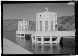
Hoover Dam, 1987.
A large portion of the Southwest’s water comes from the Colorado River. Dams constructed in 1931 (Hoover Dam), 1934 (Parker Dam), and 1966 (Glen Canyon Dam) provide stability to water access in the region. Despite the elaborate storage infrastructure on the river, past usage agreements have led to declining water levels on the Colorado. The Colorado River Compact, the primary legislative document behind the river’s water use, was formed in 1922. This was an especially wet period in the Southwest, and flow levels of the Colorado were at much higher levels than the long term average. The region’s return to typical average precipitation has placed stress upon states accessing the river, hydrologically and politically.
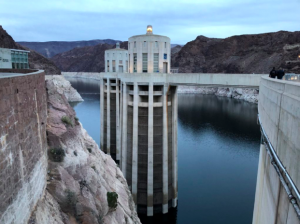
Hoover Dam, 2018.
Fortunately for the West, there is a large host of talented, driven individuals working to better society’s relationship with water in the region. This Spring, Ucross High Plains Stewardship Initiative at the Yale School of Forestry and Environmental Studies had the honor of hosting two such individuals: John Fleck and Jennifer Pitt. Both John and Jennifer have spent decades working to address the Southwest’s growing water demands through advocacy, coalition building, education, policy making, and reporting.
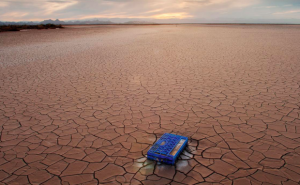
Colorado river delta, pre-pulse flow
Forming collaborations around the Colorado river involves an incredibly diverse group of stakeholders: towns, cities, farmers, industries, and ecosystems. Coalition building is also an international process as the river flows through both the United States and Mexico. Flow to Mexico was not a part of the original Colorado River Compact of 1922. This changed 22 years later with The Mexican Water Treaty of 1944, where the United States committed to 1.5 million acre-feet of water to flow through to Mexico. This 1.5 million acre-feet, however, is only one tenth the amount agreed to be used by the United States – 15 million acre-feet between the two Basins.
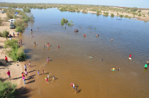
Colorado river delta, post-pulse flow
Due to this discrepancy, water use by the United States has parched the river delta for multiple decades. With amazing persistence and dedication, collaborators, scientists, and policy makers like John and Jennifer were able to coordinate a pulse flow of 106,000 acre-feet of water through the dam at the Arizona-Mexico border. This flow in March of 2014 jump started the restoration of the expansive wetland once present at the delta, restoring wildlife and bird habitat previously thought entirely lost. As the river snaked its way back to the Sea of Cortez, it restored not only wildlife; it also helped restore culture and community.
See more about the 2019 Ucross Symposium Series at http://highplainsstewardship.com/urbanization-human-wildlife-conflict-in-the-west-amy-zuckerwise/
For more on the Colorado River’s water use, see Professor Fleck’s blog at http://www.inkstain.net/fleck/.
—
Reid Lewis, Symposium Coordinator | Reid is a Master of Forestry candidate at the Yale School of Forestry and Environmental Studies. Hailing from Flagstaff, Arizona, he hopes to return to the West to aid in managing drought-resilient, fire healthy forests. With Ucross, Reid assists in brining prominent western speakers to the FES community to share valuable knowledge and perspectives about western environmental issues. See what Reid has been up to. | Blog