Gaining a Deeper Understanding of Ecosystems Through Collaboration—Rowan Sharkey

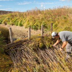
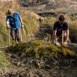
The past year working with the Ucross High Plains Stewardship Initiative has presented a wide range of experiences, connections, and memories that I find carrying me forward on the path of conservation. Throughout this process, our team has been fortunate enough to collaborate with incredible partners such as The Nature Conservancy-MT, World Wildlife Foundation, and Read more about Gaining a Deeper Understanding of Ecosystems Through Collaboration—Rowan Sharkey[…]

Evaluating Mesic Restoration Efforts in Montana with Geospatial Tools

In conjunction with The Nature Conservancy-Montana (TNC), Montana Conservation Corps (MCC), and World Wildlife Fund (WWF), our team is creating a protocol to evaluate the impacts of low-tech structures, sometimes referred to as beaver dam analogs, that have been installed in central Montana. This protocol will leverage GIS and remote sensing technologies, challenging our team Read more about Evaluating Mesic Restoration Efforts in Montana with Geospatial Tools[…]

Utilizing Geospatial Analysis to Increase Water Availability in the American West—Rowan Sharkey

Being a research assistant with the Ucross High Plains Stewardship Initiative at YSE  has afforded me a variety of opportunities to expand my knowledge in the field of mesic restoration in the western United States. Focusing on a region that is highly susceptible to drought events creates an interesting challenge when tracking water availability. The Read more about Utilizing Geospatial Analysis to Increase Water Availability in the American West—Rowan Sharkey[…]