History!
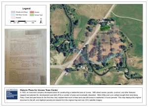
In 1932, an Iowa land company decided to build a town at the junction of routes 14 and 16, the current location of Ucross. Despite obtaining permits and drafting detailed plans, development never occurred.
Many years later, Mike (an employee of Ucross Foundation) and Lynn Latham discovered that their recently purchased, undeveloped, agricultural land along Piney Creek was zoned as residential, and subdivided into 1/4 acre parcels. After doing some investigation, they pulled up some old documents showing that this was a relic of the original development! Check out the attached map to see where the parcels would be on today’s landscape.